
Stewart Island (Rakiura) was first settled in the 13th century by Maori clans, who came to fish and hunt. It is the most southerly island of New Zealand and is quite a tourist mecca for kiwis (the feathered variety).
I’m not sad to leave Invercargill, for all its beautifully
old and neglected buildings. It is a town waiting to be discovered by the
tourist and the government for its potential, but currently it offers very little to encourage visitors to stay.
We catch the ferry at 0930hrs from Bluff. Rakiura (Stewart
Island’s Maori name) dates Maori inhabitants since the 13th century,
who hunted and fished there. There is thick cloud/fog all about us and the
Captain says he has to sound the foghorn every two minutes for the one hour
crossing of Foveaux Strait. I busy myself watching the radar scan for ships
crossing our path, backseat driving probably if I could put my foot on a pedal!
I can’t see any bearing down on our ferry and the fog clears immediately we
enter into Halfmoon Bay. Oban (the only ‘town’ of Stewart Island) has a
permanent population of 300, but tourists swell it considerably. The Stewart
Island Backpackers tells us that yesterday the management read the riot act to
guests who were drinking themselves into a stupor. Today it’s quiet. The hostel
is old, yes, but immaculately clean and comfortably cosy with lots of old sofas
in the lounge area, a large kitchen with plenty of fridges. I’d stay here again
if I ever came back to Stewart Island. It’s recently been taken on by new owners
and the daughter is the receptionist – she is very friendly and helpful.
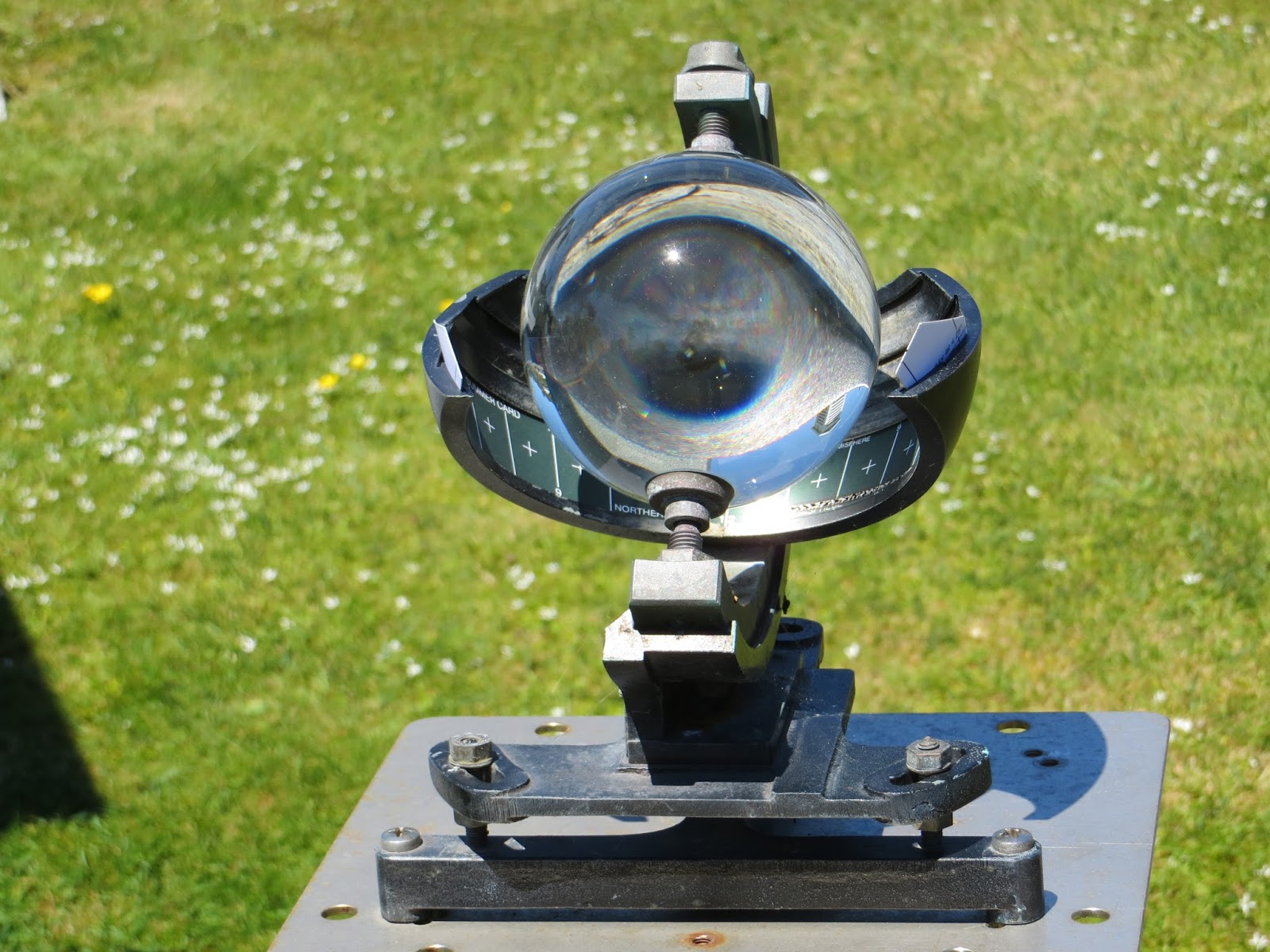
The island is used as a weather station, and this small globe shows the amount of daylight during the day by etching the data onto a paper strip. There's been no rain for over 10 days and the locals are concerned because they rely on rainwater for daily use.
This little church is perched on top of a hill - no date but it is well maintained.


Day break sees us up and backpacks ready. The Rakiura Track
is 32kms plus 6kms from Oban to Lee Bay, then an extra 2kms at the end, so we
will walk 40kms in three days. I can’t organise a taxi at this hour (8-ish) to
take us to Lee Bay, where we start the track, so we walk the 6kms to the start
of the track. The road is bitumen then onto a gravel road that follows several
pretty bays, one of which we walk along because it’s low tide, looking for
flotsam and jetsam, but the beach has only pipi shells and bits of giant kelp
washed up on the shoreline. We were warned by DOC that there was a seal
guarding the track’s starting point, but it isn’t there when we trudge by.


The telephone doesn't work, so we continue on our route!


The track is very different to the Routeburn. Although the
highest point is only 300m, we seem to climb up to that height every kilometre
or so, it’s like a switchback and I’m quickly tired of it. We reach Port
William Hut around 1pm and have lunch. The volunteer rangers are chatty and
fill us in on the goss – the kiwis have all disappeared this week, probably
because it’s very dry, there’s been no rain for 10 days, and they could be
searching for fresh water. The hut was full last night, with 20 rowdy Rotarians.
I’m glad we have a quieter bunch tonight. It’s not difficult to fall asleep but
fooling the sandflies is tricky because it’s too warm to get into the sleeping
bag, so my hands are exposed.
Dawn breaks again and I’ve downed my porridge and tea in a
jiffy. Richard has to put up with no toast or marmalade – I think he’s hungry!
Today we head over the middle section (the track goes from east coast to west
coast inlet). We have been warned of the mud but because it hasn’t rained for
ten days, the rangers say it’s dry. They are correct to a point, but each muddy
section is still squishy and the track has few firm, dry places. I’m glad, very
glad, we’re not walking when it’s wet as the track would be a nightmare.
My photos are few today because the battery power has gone
on my camera and I didn’t bring my phone (of course, why would I when there is
no power!). Somehow, somewhere, the battery charger got left behind. I’m not at
fault of course!

We spend some time investigating the Johnston log haulers
that were left by the timber millers in the late 19th century. How
those families coped with extreme isolation is beyond me. They were miles from the coast where the
logging mill operated, and built timber rail tracks for the bogies.
We pass 4 DOC workers on the track – they are trying to
repair the muddy sections (which I estimate comprise over 50% of the track) and
build new paths with deep ditches either side to capture the water run-off.
What a job. They look cheerful though and say they are in the midst of a
drought!
It takes us 6 hours to walk 13kms, much of it pleasantly
undulating, but there are still hills to climb and valleys to descend into. The
scrubby forest offers no views as we pass by, it’s dense and filled with
straggly-limbed trees, a few ferns and some flax. Even the birds are scarce and
I’m bored with looking at my feet as I trudge up and down dale. North Arm Hut
looms into view and not before time. This is a typical muddy section - it doesn't do justice to the amount of mud, but imagine that it's at least ankle deep. There has been an effort to lay logs across the mud, but they just sink further in.

There is no ranger at North Arm hut because the walking
(tramping) season doesn’t start until 1st December. And there is no
washing up liquid, which is annoying as that is the last item I’d take on a
walk. But we enjoy talking to a German woman walking on her own and a mum and her daughter and partner who've been on a working holiday in NZ for a year (mum was invited to join them before the youngsters flew back to the US).
Day 3 - North Arm Hut to Oban (11kms plus 2kms into town).
The track guide promises me that today is downhill back to
Oban, but almost as soon as I leave the hut, we climb the first hill! However,
it doesn’t go to 300m so maybe things are looking up. I can’t complain about my
backpack, it is a joy to wear. We pass plenty of streams on the way, all
twinkling with mica (fool’s gold). Richard has to poke the water just to make
sure it’s not real gold!
There is a steady descent at last, along what appears to be
a cobbled road. We think it must have been a logging road because it’s wide
enough for carts. I still haven’t seen a kiwi, nor a seal, but we do see lots
of tuis, who have the most amusing birdsong, and bellbirds, and many oyster
catchers (two were nesting on the beach as we passed into Port William, the
male flying within a hair’s breadth over my head in a clear warning not to go
closer).

Oban appears (we’ve done 13kms in 4.5 hours) and we slink
into the Backpackers and ask to buy a shower - $8 – to wash off three days of
sweat. It feels great to be clean again. The hotel beckons because they do the
most amazing Blue Cod and chips. We wash it down with Speight’s cider, what a
joy! There is no argument that freeze-dried food, e.g. Back Country, is filling
but it is disgustingly tasteless and next time we walk, I’m going to be more
inventive than rely on packaged freeze-dried food.


